Week 4 : 16 hours
9/21 – 9/25
3213 Middle Street Project – Sullivan’s Island
Monday : 4 hours
I spent time today researching and looking through a few extension programs for SketchUp. I have always just used different styles of the drawing exported from SketchUp, (casted shadows, rough edge lines, color, etc.) layering and editing them in photoshop to create renders. I have v-ray on my computer for SketchUp, but have never really put it to use. Steve and I were talking about a rendering of a particular sunset view, and I became curious if I could get better results with v-ray. I am busy working on a few projects right now as well, but this is something I’ll definitely continue to look towards.
Tuesday : 4 hours
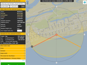
Today, I had a zoom meeting with Steve. We talked about the render I completed for 3213 Middle Street and found a few changes he wanted to make to the plans. It is amazing how different a house can look in 2D verses when you see it in a 3D program like SketchUp. We also discussed how to get an accurate location of a sunset for an oceanfront house during the month of December. I was able to figure that out (I will discuss in the lessons learned section) and get him that site/sunset analysis.
Wedensday : 4 hours
Today I pushed forward with changes to the SketchUp model for 3213 Middle. I was able to change the roof to a hip-roof, scale a few items down, and work on some interior walls that needed adjusting and moved.
Thursday: 4 hours
I continued working on more changes to the 3213 Middle model. There were a few windows on the rear elevation that needed adjusting before making a rendering of that side, as well as a few more adjustments to some roof lines and the front porch. I should wrap these up over the weekend or Monday morning, and have a few new renderings to go in the DRB packet next week.
Weekly AXP Hours: 14 hours / Project Development & Documentation
2 hours / Programming & Analysis
Weekly Lessons Learned: This week, I learned something awesome. I was challenged with locating the sunset for a specific oceanfront site during the winter (December – winter solstice). They clients want to angle their house where they can maximize this view. I’ve never done anything like that before, but I was determined to figure out how. I went to the Google Earth Pro app and found the coordinated relating to that specific site/address. I was able to determine the altitude, etc. as well. I then found a sun path website where I was able to enter the information found, along with a specific date and time of day. It then gave me a map (image below) with the sun path for the day. I could then zoom in on the site and get correct angles that line up with the sun path. This was so cool to accomplish, as I never have even thought that it was possible.